Nobody knows one Western Massachusetts trail quite like Scott Lewis.
By Larry Parnass
Bird songs trill as Scott Lewis swings the big Williams College Outing Club van off Pine Cobble Road, headlights raking the parking area as he pulls in. It is 6:07 a.m. on a Friday in April, 17 minutes before sunrise over Williamstown, Mass.
It would be news if Lewis wasn’t here. In the 25 years he’s run the college outing club, Lewis has been bugling students up and at ‘em for this three-mile sunrise climb up Pine Cobble nearly every Friday, in all weather.
They come in downpours. On snowshoes. Atop microspikes. Through brilliant foliage and, the other day, along a sodden trail and through stands of bare trees, ascending 1,100 feet ahead of the morning’s drizzle, pausing to adjust layers as the morning chill burned off even on an overcast day.
“It’s the perfect amount of exercise in the morning,” Lewis said later that morning, back at his office in the Paresky Student Center at Williams College.
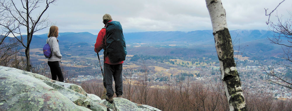
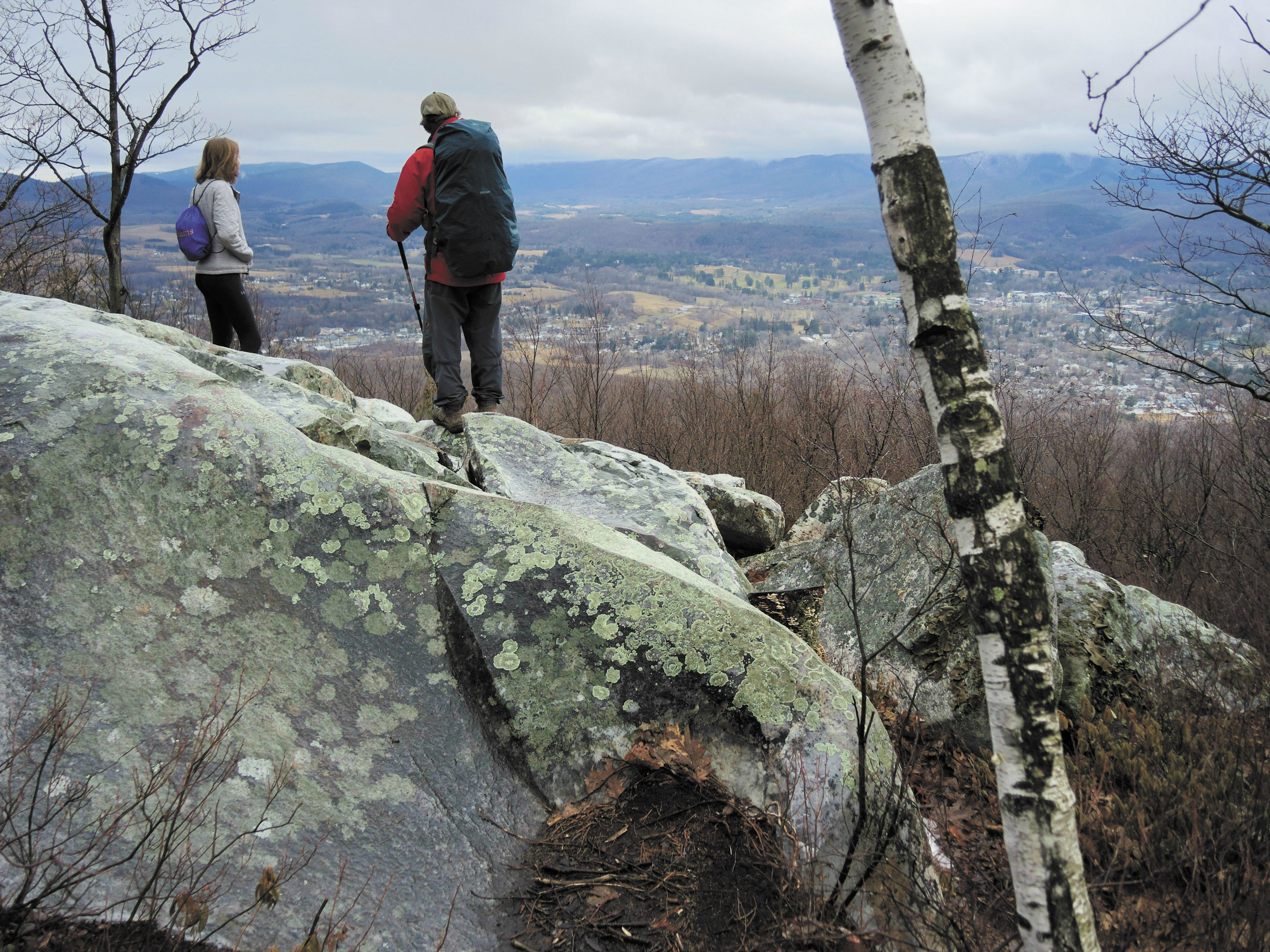
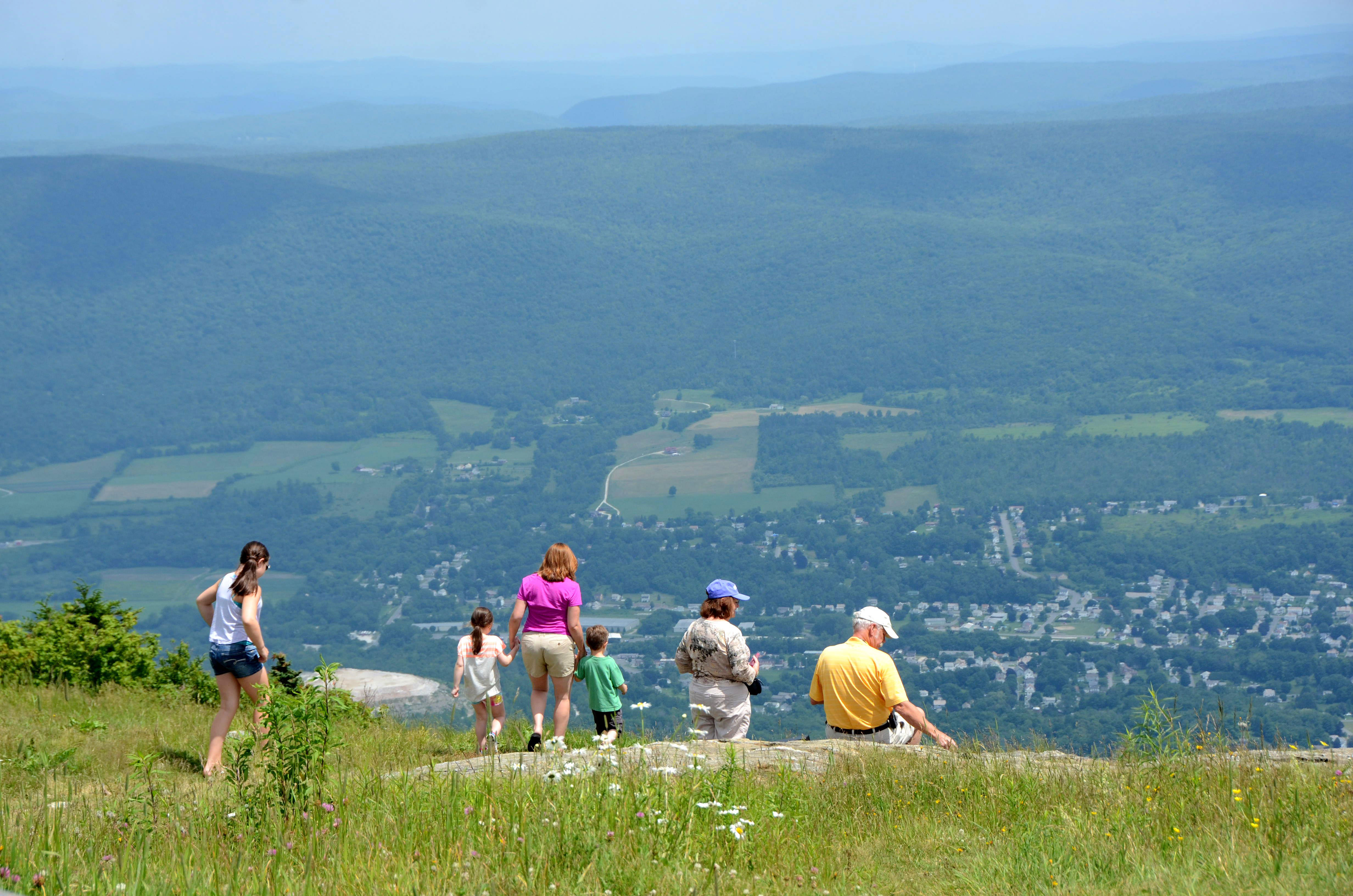
On this Friday, Lewis — a compact, athletic man of 58 — led two companions up the trail. It can be more than 50 hikers, though, as multiple vans pull in and the assault on Pine Cobble stretches out in a long line over brooks, through glades and up this trail’s occasionally steep climbs en route, over the course of a mile and a half, to a big reward: views both to the east and west on the Pine Cobble ridge.
In his time directing the outing club as a Williams faculty member, Lewis has climbed this trail more than 600 times.
He keeps coming back. UpCountry wanted to know why.
“It’s new to me every time because I’m sharing it with students,” Lewis said. “It’s always renewed, every time somebody new shows up and I’m hearing, ‘Wow.’ I’m seeing it through new eyes.”
“It’s a great three-mile hike,” he adds. “Beats any treadmill I’ve ever seen. That’s why, 25 years later, I’m still doing it. To be able to breathe some clean air in the morning and go out. It’s pretty special.”
JUST RIGHT
For Lewis, the Pine Cobble trail, whose trailhead lies a five-minute drive from campus, is simple perfection.
He can deliver students back from a hearty climb in time for 8:45 a.m. classes. They can get a workout, and immerse themselves in the woods, without having to extract themselves from their daily lives — or by having to show up before 6 a.m. That hour, he’s found, is about as early as he dares to call muster, even for outing club stalwarts.
Because this ridge with rock outcroppings runs north-south, it provides views both to the Hoosac Range to the east, past North Adams, and down, on the other side, into Williamstown, where the campus lolls in picture postcard splendor. To the east, hikers look across a near ridge carrying the Appalachian Trail. To the west hangs the big curtain of the Taconic Range.
The destination matters, but it isn’t everything. After reaching the top of the ridge hundreds of times, Lewis can’t claim to see much new, though the other day he did pause to refresh his sense of exactly where, down below, sat the local airport.
As the guiding spirit of the outing club’s sorties up Pine Cobble, Lewis encourages his companions to appreciate all they pass on their way to these views. Getting there matters, as he sees it.
“When you hit it on some of those snowy days,” Lewis said, when asked about special times, and places, in his hundreds of hikes here. “When there are ice crystals in all the branches. And in the spring now, when all the wildflowers are just about to bloom and bust. And in the fall when the colors are changing and you’re walking through a rainbow up there.”
He keeps the pace brisk, but not so fast people can’t talk. Still, conversation is optional. Just being out here, crossing this brook, or picking your way among rocks, requires attention. Lewis wants his hikers to absorb that.
“Working here, I see students so tuned out,” he said. “They’re stressed with their school work, but any free moment is on the iPhone. It is certainly striking to me how people just don’t have any time to reflect. They’re just going from one thing to the next thing and the next thing and checking things off.”
“At least going out in the woods you have to be present — if you put your phone down. You have the natural sounds, you really don’t need to muffle those. Right now it’s spring. The peepers are out. The American woodcock is out. It’s happening now in the fields.
“I just personally believe that it’s extremely important to be present. And I think the woods can give you that kind of presence if you’re willing to embrace it and to put your phones down and to have a conversation with somebody on a hike. It renews the spirit.”
He recalls a time when a group of physics students joined the sunrise hike. “They got some extra homework points for getting up early. I guess they were learning about gravity — and going against it.”
UPHILL WALKERS
After pulling into the trailhead lot on this Friday, Lewis swings open the two big doors at the back of the van and sorts through his traveling commissary. He’s expert at this after preparing trail snacks for three decades.
One of his two companions will carry the bagels and doughnuts. He’s packing the big thermos of coffee and the equally big jug of hot chocolate. In 90 minutes, he’ll be passing around steaming cups as mists drift across near ridges and the sun, already risen, remains shrouded behind morning clouds over the Hoosac Range.
The trail is clear this early spring day, though ever in a custodial spirit, Lewis toes aside a few fallen branches. In summer, a regular crew attends to bigger projects on the Pine Cobble approach.
One section of the trail, more than halfway up, runs with water. Past projects have installed stone bars on the trail surface to channel water away and reduce erosion. But not entirely.
Lewis is full of questions for his companions on the way up. At nearly a mile and a half in, nearing the top of the ridge, he pauses at a novel tree: an old oak, once cut, that sprouted three new trunks and developed a water-filled basin between them. Lewis calls it the “elf and fairy” tree.
If you see your reflection, he says, make a wish. This time of year, the state flower, trailing arbutus, pops up wild along this section.
Lewis keeps an eye on his travelers, on this trip — and all the others. As if he’s written this book and they’re his first readers.
“You can sense that they’re taking it in. These are sharp kids,” he said of those who join him. Two emails a week keep students alerted to outing club adventures, including the Friday hikes. Lewis never tires of making the pitch.
“Just to even see the sunrise. I tell the kids, ‘You’re going to have endorphins all day long.’ It’s worth getting up. Besides the beauty that hits you, and sinks right into your soul, you’re going to be energized for the whole day.”
Peter Wells, a fellow faculty member, catches up with Lewis’ expedition at the top. The day before, Wells and Lewis hiked the Hopkins Memorial Forest. When college is not in session, Lewis gives Pine Cobble a break and heads for trails throughout the region.

Up at the top, Wells accepts a snack and visits with a Williams student, who he discovers grew up in the same town he did, Sudbury.
The group takes in the view, adjusts clothing against the weather and absorbs the feeling of wind and a booming silence on the hilltop. At 1,864 feet, the ridge isn’t much to brag about, but the vistas are big and clear, thanks to the quartzite bedrock outcroppings that give the “cobble” its name.
“Every Friday, it’s clockwork,” Wells said of his friend’s trips. “He gives so much to the community. He is a total giver and he would never think of himself as that,” he said of Lewis.
It’s Pine Cobble that gives, Lewis suggests later, quoting Henry David Thoreau about one’s good fortune to live near the base of a mountain.
The trailhead is so close to campus it’s irresistible. And the route up gets the blood pumping, even for him.
“You earn it, but it’s not a killer hike,” Lewis said. And once up, it doesn’t disappoint. “It is a spectacular view. There are not that many places here where you get views like that. There are are very few lookout views. There are lots of wooded trails and lots of places you go, but rarely can you pop out and get two views.”
Lewis and the Williams student hurry back down the trail to make that first morning class.
Back on campus, Lewis sits at a conference table in the club’s headquarters, flames lighting up a fireplace one story below.
Laptops and phone screens glow throughout the student center.
“Wilderness is the salvation of the world, if you’re that disconnected,” Lewis said. “And you won’t treat the planet that we need so much as something special if you’re so disconnected.”
Lewis credits the college with keeping the outing club supplied and active. As far as he’s concerned, trips into the woods help define higher education.
“They’re making a statement about how important it is to look up.”
UpCountry Trail Guide
The Shires of Southern Vermont and Western Massachusetts are laced with hiking trails, some famous for recreation, others born out of human activity going back centuries.
Here is a highly selective list of walks worth taking in any weather. We picked treks that showcase a variety of UpCountry environments.
We shine a light on lesser-known routes. But we hasten to add: If you are in good shape and plan just one outing this summer, head up Mount Greylock in Adams, Mass.
Pine Cobble, Williamstown, Mass.
ABOUT: Our main hiking story in this issue presents this modest but rewarding route through the eyes of a man who has climbed it more than 600 times. Thanks to outcroppings of quartzite bedrock, visitors get two open views, one east, one west.
LENGTH (ROUND TRIP): 3.2 miles
ELEVATION GAIN: About 1,100 feet
DIFFICULTY: Moderate
TIME: 2 hours
TRAILHEAD LOCATION: Parking area on Pine Cobble Road, off North Hoosac Road in Williamstown. GPS: 42.716146, -73.185280
WHAT TO LOOK FOR: The “elf and fairy” tree
WHY WE LIKE IT: If you go early on a Friday when college is in session, you can hike with a true naturalist, Scott Lewis, director of the Williams College Outing Club.
INFORMATION: The Williams College Outing Club helps maintain the trail. 413-597-2317
Lye Brook Falls, Green Mountain National Forest, near Manchester, Vt.
ABOUT: Just minutes from Manchester, this trail wastes no time in taking hikers up into the Lye Brook Wilderness.
LENGTH (ROUND TRIP): 4.6 miles
ELEVATION GAIN: 740 feet
DIFFICULTY: Moderate
TIME: 3 hours
TRAILHEAD LOCATION: From East Manchester Road on the southeast side of Manchester center, take Glen Road south to the Lye Brook Falls Service Road and continue for less than half a mile to the trailhead. GPS: 43.158937, -73.041380.
WHAT TO LOOK FOR: Following the trail’s blue blazes, listen for the sounds of Lye Brook to the west, which parallels the route. Close to the top, look for evidence of a landslide from an old storm’s inundation.
WHY WE LIKE IT: The trail brings hikers to one of the highest waterfalls in Vermont, with its 125-foot cascade.
INFORMATION: Green Mountain National Forest HQ, 802-747-6700
Busby Trail to Spruce Hill, Savoy Mountain State Forest, Savoy and Florida, Mass.
ABOUT: This high country isn’t far from Route 2 to the north and Route 8 to the west, but for much of the winter, it is sealed off by snow and mud. The 1,200-acre forest sprawls into Adams and North Adams as well.
LENGTH: 3 miles
ELEVATION GAIN: 680 feet
DIFFICULTY: Moderate to strenuous
TIME: 2 to 3 hours
TRAILHEAD LOCATION: Start from near the forest headquarters building at 260 Central Shaft Road, near Old Florida Road and about 3 miles south of Route 2 in Florida. Pick up a trail map at the office or download one ahead of time from the state Department of Conservation and Recreation website, mass.gov/eea/docs/dcr/parks/trails/savoy.pdf. Park on the shoulder of Old Florida Road. GPS: 42.658002, -73.055716.
WHAT TO LOOK FOR: The Busby Trail is named for the former Busby Farm, which has retreated to a cellar hole, barn foundation and stone walls. It operated from the early 1800s to 1933, when the land was purchased to create the state forest.
WHY WE LIKE IT: The view west into the Hoosac Valley from the open rock summit of Spruce Hill, at 2,570 feet, is impressive.
INFORMATION: State forest office at 260 Central Shaft Road, Florida, 413-663-8469
Ridgeline Trail, Alford Springs, Alford, Mass
ABOUT: This 884-acre property owned by the Berkshire Natural Resources Council lies along the north-south Taconic Mountains and includes both trails and woods roads. It is an example of a private group’s determined conservation effort, which won out over a proposed development of high-end houses.
LENGTH: 4.3 miles
ELEVATION GAIN: 600 feet
DIFFICULTY: Moderate
TIME: 2 to 3 hours
TRAILHEAD LOCATION: From Route 41 in Great Barrington, take Taconic Avenue then Alford Road to Seekonk Road. Follow that for 3.6 miles and turn right on Mountain Road. Proceed 0.8 miles, bearing left at the first “Y” and then left again when the road bends sharply to the right to come up a small dirt road to trailhead parking and a gate. For a trail map and guide, visit bnrc.org/trails-and-maps. GPS: 42.2482, -73.4458
WHAT TO LOOK FOR: Black bear and even bobcat, according to the property’s champions.
WHY WE LIKE IT: Its seasonal treasures: blackberries in summer, cross-country skiing in winter in a remote location a whisper away from the New York State line. The parcel offers a satisfying variety of roads and trails.
INFORMATION: Berkshire Natural Resources Council, 413-499-0596
Other trails worth considering:
FOR THE CHALLENGE: Mount Prospect Trail off the north shoulder of Mount Greylock. The route demands hikers climb 1,000 feet of elevation in a mile.
FOR THE NOVELTY: The Valley Trail links Dover and Wilmington, Vt. An interesting option for those who like to stick close to civilization.
TO BAG TWO PEAKS: Mount Everett and Mount Race in South Egremont, Mass. The 7.2-mile route is strenuous, with 2,200 feet in elevation gain.
TO KNOW A LANDMARK: Mount Ascutney, in Windsor, Vt., offers a 6.4-mile, five-hour hike that is moderate but brings hikers up 2,400 feet in elevation gain on a mountain near the Connecticut River, handy to I-91.